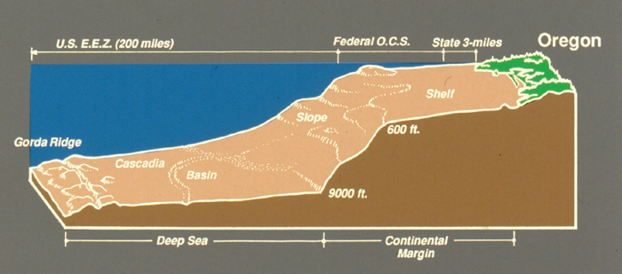
Continental Shelf
The Oregon outer continental shelf is fundamentally shaped by the dynamics of the Pacific Ocean, where the ongoing process of plate tectonics dictates its geological structure. This margin sits at a convergent boundary, specifically the Cascadia Subduction Zone, where the oceanic Juan de Fuca plate is actively sliding beneath the North American continental plate. This tectonic activity is responsible for the narrowness of the shelf, the formation of the Coast Range, and the high potential for significant earthquakes. Over this geologically active foundation, the broad, southward-flowing California Current system influences the physical oceanography by driving seasonal coastal upwelling, which brings cold, nutrient-rich deep water onto the shelf and makes the region one of the Pacific Ocean's most biologically productive environments. Thus, the OCS is a complex intersection of deep-earth geological forces and dynamic oceanic currents.
The State of Oregon maintains an interest and is an active participant in the activities that occur on the Outer Continental Shelf (OCS) beyond the State's Territorial Sea boundaries. This section of our site describes aspects of the State's interest and applicable authorities related to OCS management. It also provides information regarding ongoing continental shelf activities at the State and Federal level. The most recent area of work related to OCS waters is a focus on offshore wind energy planning, through the Bureau of Ocean Energy Management, the federal agency with authority to lease lands on the OCS.
The Oregon Ocean Stewardship Area
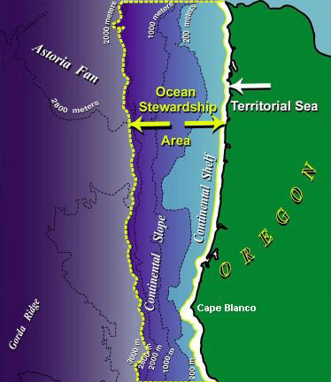
Because the ocean is part of a much larger regional marine ecosystem, ocean uses and activities that occur in federal waters may affect Oregon's coastal environment and communities. For this reason, in 1991, the State of Oregon defined an Ocean Stewardship Area in the Ocean Resources Management Plan as the area extending through the state’s territorial sea out to the toe of the continental shelf.
The Ocean Stewardship Area is Oregon's area of direct concern and responsibility for ocean resource management. The Ocean Stewardship Area includes the entire continental margin from mean high water, across the continental shelf, and down to the bottom of the continental slope. Oregon does not claim ownership or possession of the entire Ocean Stewardship Area.
Designation of the Ocean Stewardship Area will neither change the jurisdictional boundaries of the state, nor change the federal legal regimes under which the resources of the exclusive economic zone are managed. Designation will not expand the state's federal consistency authority beyond activities which affect Oregon's coastal zone.
Within the Ocean Stewardship Area:
- Ocean resource uses and activities directly affect the interests of the State of Oregon;
- Oregon has management interests in oil and gas exploration and development, marine mineral mining, marine transportation and ports, marine birds and marine mammals, intertidal areas, ocean fisheries, oil spills, recreation, cultural resources, aesthetic qualities, and water and air quality;
- Oregon shares management responsibilities and interests in concert with federal resource management agencies.
Within the Ocean Stewardship Area, Oregon will:
- Conserve living marine resources, including biological communities and habitats;
- Give priority to renewable resources over nonrenewable resources;
- Support scientific research on marine ecosystems, ocean resources, and oceanographic conditions to develop better information upon which to make better ocean management decisions;
- Seek appropriate co-management arrangements with the federal government to ensure that ocean resources in the Ocean Stewardship Area are managed consistently in accordance with the policies of the Oregon Ocean Resources Management Plan;
- Coordinate and cooperate with adjacent states and encourage regional approaches to management of ocean areas, where appropriate:
- Involve local governments and the public in ocean resource management decisions;
- Develop marine management areas, where needed, to provide increased opportunities for public recreation, to protect biological communities and habitats, and/or to advance scientific understanding of the ocean.
Authorities Supporting the Ocean Stewardship Area:
The concept of an Ocean Stewardship Area is framed in the Oregon Ocean Resources Management Act of 1987 and fully described in the Oregon Ocean Plan of 1990. The Ocean Stewardship Area is defined and the state’s interests described by Oregon’s Statewide Planning Goal 19, is as follows:
"The State of Oregon has interests in the conservation of ocean resources in an Ocean Stewardship Area, an ocean area where natural phenomena and human uses can affect uses and resources of Oregon’s territorial sea...
The Ocean Stewardship Area includes the state’s territorial sea, the continental margin seaward to the toe of the continental slope, and adjacent ocean areas. Within the Ocean Stewardship Area, the State of Oregon will:
- Use all applicable state and federal laws to promote its interests in Management and conservation of ocean resources;
- Encourage scientific research on marine ecosystems, ocean resources and uses, and oceanographic conditions to acquire information needed to make ocean and coastal-management decisions;
- Seek co-management arrangements with federal agencies when appropriate to ensure that ocean resources are managed and protected consistent with the policies of Statewide Planning Goal 19, Ocean Resources, and the Territorial Sea Plan; and
- Cooperate with other states and governmental entities directly and through regional mechanisms to manage and protect ocean resources and uses.
The Ocean Stewardship Area is not intended to change the seaward boundary of the State of Oregon, extend the seaward boundaries of the state’s federally approved coastal zone under the federal Coastal Zone Management Act, affect the jurisdiction of adjacent coastal states, alter the authority of federal agencies to manage the resources of the United States Exclusive Economic Zone, or limit or otherwise change federal agency responsibilities to comply with the consistency requirements of the federal Coastal Zone Management Act."
Offshore Wind Energy Planning
House Bill 4080, passed in the 2024 legislative session, has tasked the Department of Land Conservation and Development with the development of an Roadmap for the state. Visit the OSW Roadmap pages to learn more.
What is a GLD and why did Oregon want one?
A GLD (or Geographic Loaction Description) is an area within federal waters where listed federal license or permit activities have reasonably foreseeable effects on a states coastal uses or resources. Meaning that federal permitting or leasing may potentially impact waters in the states jurisdiction (the territorial sea). The process for creating a GLD is outlined by the federal Coastal Zone Management Act (CZMA). Oregon’s GLD is designed to ensure that marine renewable energy projects within the GLD are automatically subject to the federal consistency review process, ensuring that those actions are consistent with the enforceable policies of Oregon’s coastal management program.
How does the GLD work?
A GLD is based on a demonstration that there would be reasonably foreseeable coastal effects from the listed federal license or permit activity in the proposed area. Oregon’s GLD applies specifically to federal activities related to marine renewable energy development; which includes leasing and permitting authorized by the federal Bureau of Ocean Energy Management (BOEM). The activities, such as authorizing a permit or lease, are automatically subject to federal consistency within the GLD. To learn more about BOEM visit the BOEM Oregon Task Force page.
In 2015, DLCD completed an analysis of reasonably foreseeable effects of Federal actions related to marine renewable energy projects on resources and uses occurring within the GLD. You can download the report associated with this analysis here.
The Oregon Department of Land Conservation and Development maintains this website. Please contact the Marine Affairs Coordinator below for more information or with comments.
Andy Lanier
Marine Affairs Coordinator
635 Capitol St. NE, Suite 150
Salem, OR 97301-2540
Andy.Lanier@dlcd.oregon.gov