About
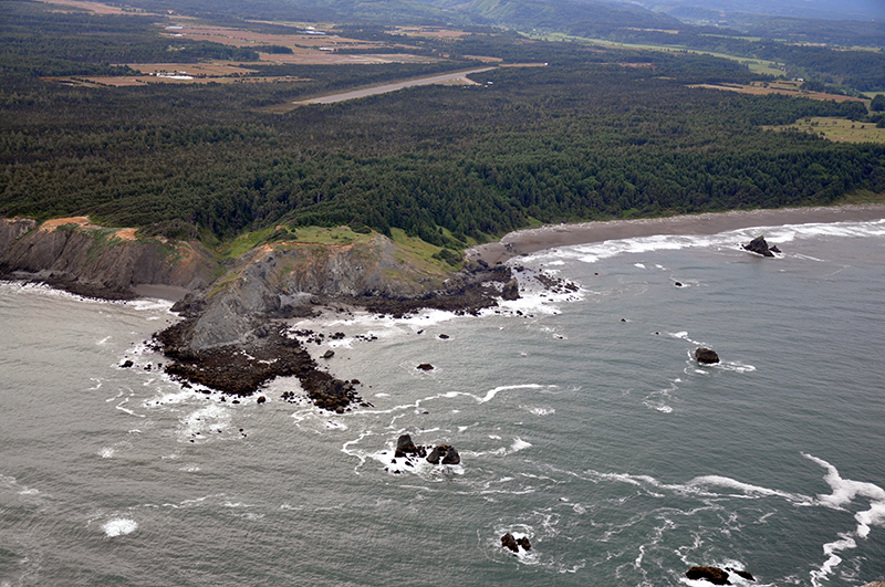
Blacklock Point is a Marine Conservation Area
Marine Conservation Area regulatory restrictions vary by site. Blacklock Point is designated as such to educate, monitor, and apply ecosystem-based management to conserve the ecological structure of the rocky habitat species facing effects of changing climate.
There are no changes to the existing statewide harvest regulations for fish, invertebrates, or plants.
Features
Key Resources
Relatively undisturbed rocky intertidal communities. Harbor seals and California sea lions use rocky areas near the tip of Blacklock Point to haul out. A portion of the upland is a pygmy pine forest and the area was used historically as a sandstone quarry.
Site Uses
Use of the area is relatively low due to the remote nature of the site and includes sightseeing, hiking on the adjacent Oregon Coast Trail, fishing from shore and some tidepooling.
Access
A 1.5 mile-long trail (one way) through forest from the Cape Blanco airport to the point then a climb down a steep slope to the intertidal area. The gravel trailhead parking area can be reached by turning off HWY 101 a few miles south of the small town of Denmark, across from Pacific High School. There is a small sign pointing to the airport, turn on Airport Road, and go past the cranberry bogs (total driving distance off 101 is approximately 3 miles). The road ends in a barrier for the Cape Blanco Airport. There is limited parking near the sign for Blacklock Point, or by following the small gravel road to a larger parking area. Follow the main trail and signs to Blacklock Point. Trail access by way of the Boice-Cope County Park is also possible.
Management
Site Management
Floras Lake State Natural Area is an undeveloped OPRD property, which is part of Area 4 (Southwestern Oregon), and the Cape Blanco Management Unit. Oregon Parks and Recreation Department manages the ocean shore recreation area.
Regulations
No special restrictions, follow statewide ODFW harvest rules.
Ownership
- Submerged and submersible (intertidal) lands: Department of State Lands;
- Offshore rocks above Mean High Water: U.S. Fish and Wildlife Service;
- Upland above MHW and dry sands beach areas and uplands: Oregon Parks and Recreation Department.
Plan
Plan Development
OCMP is facilitating a two-part public workshop series in 2024 and 2025 to help inform the development of area-based management plans. OCMP will host five workshops in September and October 2024 followed by the second series in early 2025. Coastal communities will inform these site management plans, using them as a guiding framework to support activities within the protected areas. The OCMP workshop series is open to the public and includes a 15-minute public comment period.
Get involved
The first workshop is intended for professionals and volunteers with interest or experience in rocky habitats, local jurisdictions, coastal tribal staff, state and federal agency staff, and other interested parties. Members of the public are welcome to share their perspectives during the public comment period. There will be more opportunities for public comment and engagement on this process in 2025.