About
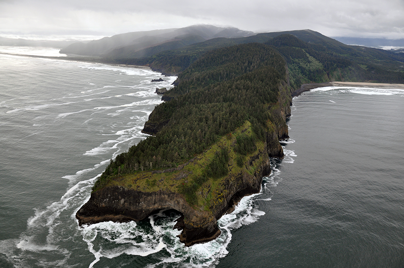
Cape Lookout is a Marine Conservation Area
Marine Conservation Area regulatory restrictions vary by site. Cape Lookout is designated as such to educate, monitor, and apply ecosystem-based management to conserve the ecological structure of the rocky habitat species facing effects of changing climate. There are no changes to the existing statewide harvest regulations for fish, invertebrates, or plants, except subtidal kelp harvest is now closed*.
Features
Key Resources
Two seabird colony sites on the south cliff face with over 10,000 birds total (Oregon's largest mainland common murre colony; double-crested, pelagic, and Brandt's cormorant; pigeon guillemot; western gull; tufted puffin; black oystercatcher; bald eagle; peregrine falcon); productive and diverse rocky intertidal habitat; one of the only bull kelp (Nereocystis) beds on the north coast. Harbor seals use rocks in the area as a haulout.
Site Uses
Typical use of the adjacent ocean shore area and trails includes beachcombing, dog walking, surfing, and sightseeing. Trail hiking through the forest to the tip of the cape for whale watching and general scenic views appears to be the primary use of the cape. Actual use of the rocky shore areas is relatively low because few visitors hike to the intertidal area from the cape trail. Surfers, SCUBA divers and boats seeking protection from the wind use the ocean waters below the south cliff face. Camp Clark uses the rocky intertidal area for outdoor education. Use of the northern beach (off the campground) is much higher and includes sport fishing from shore, beachcombing and other general ocean shore recreational activities.
Access
The site is located within Cape Lookout State Park, which is off US 101, approximately 12 miles southwest of Tillamook, Oregon on the Three Capes Scenic Route. Access to the south end intertidal areas is possible either via a private access point at the Camp Clark Boy Scout camp to the south or via a long, steep trail from Cape Lookout State Park. A trail traverses the entire length of the cape and in places is at the top of the south cliff face. There is no access down the face of the cliff.
Access from the Cape Lookout State Park day-use area is on a moderate to difficult, semi-improved dirt trail (the North Trail) which winds 2.3 miles to the trailhead parking area (see below), this takes about an hour at a moderate pace.
The trailhead parking area (to the south of the actual park) provides direct access to the South Trail (1.8 mi. semi-improved moderately difficult), which splits off from the Cape Trail, and winds down to the beach
To gain visual access to much of the cape, including many views of the rocky shore below, take the Cape Trail from the trailhead parking area. From there, the walk follows an easy to moderate semi-improved dirt path with some portions covered by wooden walkways (over the wet areas). This hike takes approximately one hour to the tip of Cape Lookout at a moderate pace. In some sections it becomes necessary to climb over roots and fallen trees. Other visual access is afforded at Anderson Lookout, approximately 2 minutes (driving time) south of the park.
Management
Site Management
Oregon Parks and Recreation Department manages the entire cape (as Cape Lookout State Park) for general recreation and natural resource use. Cape Lookout State Park is part of OPRD Area 1 and the Cape Lookout Management Unit.
Regulations
No take of shellfish and other invertebrates in the intertidal except clams, Dungeness crab, red rock crab, mussels, piddocks, scallops, and shrimp may be taken.
Ownership
- Submerged and intertidal lands: Department of State Lands;
- the beach and upland are owned by Oregon Parks and Recreation Department as Cape Lookout State Park.
Plan
Plan Development
OCMP is facilitating a two-part public workshop series in 2024 and 2025 to help inform the development of area-based management plans. OCMP will host five workshops in September and October 2024 followed by the second series in early 2025. Coastal communities will inform these site management plans, using them as a guiding framework to support activities within the protected areas. The OCMP workshop series is open to the public and includes a 15-minute public comment period.
Get involved
The first workshop is intended for professionals and volunteers with interest or experience in rocky habitats, local jurisdictions, coastal tribal staff, state and federal agency staff, and other interested parties. Members of the public are welcome to share their perspectives during the public comment period. There will be more opportunities for public comment and engagement on this process in 2025.