About
Ecola Point is a Marine Conservation Area
Marine Conservation Area regulatory restrictions vary by site. Ecola Point is designated as such to preserve and strengthen the ecological integrity of the site through education, monitoring, and implementation of an ecosystem-based management system. No change to fish harvest beyond baseline ODFW regulations. No take of invertebrate or marine plant harvest in the intertidal except for single mussels for recreational bait and scientific research permits*.
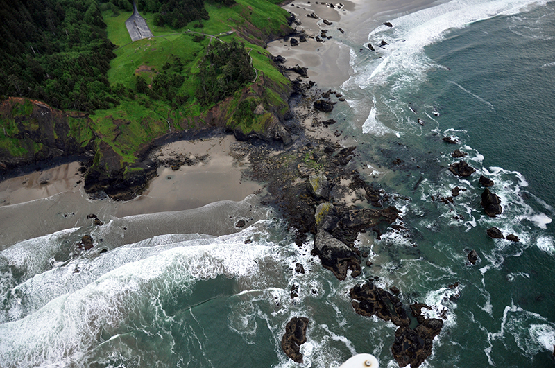
Encompasses shoreline and ocean along the headland from 194 yards northeast of the tip of Bald Point to 176 yards north of Waterfall Creek to the south, encompassing beaches and nearshore rocks within the site polygon.
Features
Key Resources
Intertidal areas have typical assemblages of marine invertebrates. Sea Lion Rock, associated unnamed small rocks, and cliff face are breeding habitat for five species of seabirds including bald eagles, brown pelicans and common murres. Steller sea lions and harbor seals use rocks in the area as haulouts.
Site Uses
The majority of visitors use the upland park area for picnicking and sightseeing. Some visitors explore tidepool areas and beachcomb. The beaches in the area are popular surfing spots.
Access
The site is immediately adjacent to Ecola State Park, and within the park can be accessed via the Ecola Point parking area (the first of two parking areas off the main park road). Ecola State Park can be found west of US 101 (on Ecola Park Rd.), 2 miles north of downtown Cannon Beach, Oregon.
Some of the rocky shore is accessible from Crescent Beach (which is accessed easily by way of an improved trail from the Crescent Beach parking lot). Another way to get down to the rocky shore is via a trail, which starts out on the south side of the parking area and is approximately 1 mile long (one-way).
Map
Management
Site Management
Oregon Parks and Recreation Department (OPRD) manages public access and recreation on the ocean shore. This site is within OPRD Area 1 and part of the Nehalem Bay Management Unit.
Regulations
No take of shellfish and other invertebrates in the intertidal with the exception of single mussles (for bait)
Ownership
- Submerged and submersible lands (intertidal area): Department of State Lands;
- rocks above Mean High Water: U.S. Fish and Wildlife Service;
- upland is all owned by Oregon Parks and Recreation Department (OPRD).
Plan
Plan Development
OCMP is facilitating a two-part public workshop series in 2024 and 2025 to help inform the development of area-based management plans. OCMP will host five workshops in September and October 2024 followed by the second series in early 2025. Coastal communities will inform these site management plans, using them as a guiding framework to support activities within the protected areas. The OCMP workshop series is open to the public and includes a 15-minute public comment period.
Get involved
The first workshop is intended for professionals and volunteers with interest or experience in rocky habitats, local jurisdictions, coastal tribal staff, state and federal agency staff, and other interested parties. Members of the public are welcome to share their perspectives during the public comment period. There will be more opportunities for public comment and engagement on this process in 2025.