About
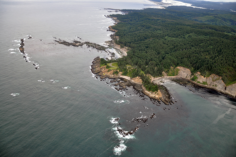
Cape Arago is a Marine Research Area
Marine Reseach Areas are subtidal and/orintertidal areas that allow for research while maintaining ecological integrity. Generally, these areas are closed to the take of invertebrates; however, there are exceptions at some areas for commonly harvested invertebrates. Angling is allowed in most areas.
Features
Key Resources
Rich, relatively undisturbed intertidal habitat. Some of the only rocky intertidal habitat between Cape Arago and Bandon with limited seabird and harbor seal use of nearby offshore rocks.
Site Uses
North cove has a fairly low level of use, includes scientific research, sport fishing from shore, sightseeing/wildlife viewing from the overlook and tidepooling. At Middle cove, typical uses include beach recreational activities like beach combing and some tidepooling, bird watching, along with some mussel and razor clam collecting.
Access
At north cove, there is a trail from Cape Arago State Park to the cove beach, with low tide foot access through the tidepools/over the sand spit to Shell Island; visual access from scenic overlook on Cape Arago Highway; boat access from launch at Sunset Bay in good weather and from the mouth of Coos Bay. The official trail from Cape Arago State Park starts from the southern end of the parking area (by the cluster board/park signage). The trail splits, at which point a right turn goes towards the beach. The trail soon forks a second time into three paths at signage indicating the protected status and vulnerability of marine mammals. Turning left brings you to picnic tables, going straight affords visual access by way of a fenced overlook. The official path to the beach/rocky area is reached by turning right at the three-way fork, where the paved path leads down a short ways to shore level. This path is closed by OPRD from March 1st- June 15th to protect marine mammals during pupping and rearing season. Visual access is afforded from the Simpson Reef overlook off the Cape Arago Highway.
At middle cove, there is a steep, unimproved (unofficial and not maintained) trail from Cape Arago State Park, just south of the parking area.
Management
Site Management
At North Cove, the intertidal is managed as in the research reserve by Oregon Department of Fish and Wildlife and the upland by Oregon Parks and Recreation Department (OPRD) as Cape Arago State Park (OPRD). OPRD manages the ocean shore recreation area. At Middle Cove, Seven Devil’s State Recreation Site to the north is part of ORPD area 4 and is in the Bullards Beach Management Unit. Oregon Parks and Recreation Department manages the ocean shore recreation area.
Regulations
No take of shellfish and other invertebrates in Areas A and C. No take of invertebrates in Area B**. Site boundary: Intertidal in the following areas:
- Area A: Between a line projected due west from Cape Arago lighthouse and the southern tip of Norton Gulch.
- Area B: Between the southern tip of Norton Gulch and Simpson Reef overlook.
- Area C: Between Simpson Reef overlook and a point ¾ mi south of Cape Arago State Park.
Ownership
- Submerged and submersible (intertidal) lands: Department of State Lands;
- adjacent upland: Oregon Parks and Recreation Department (Cape Arago State Park).