About
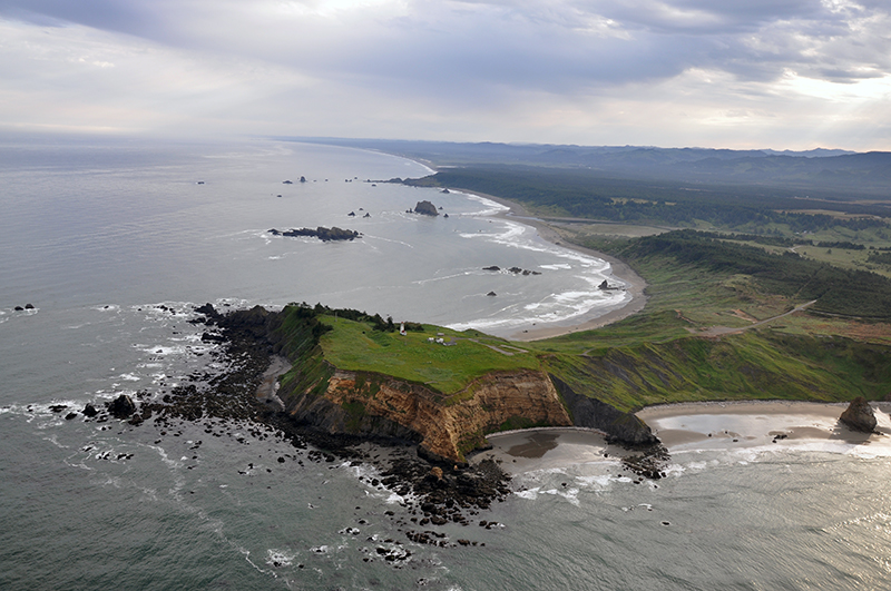
Cape Blanco is a Marine Research Area
Marine Research Area regulations vary by site. These areas are designated to maintain the natural systems, to support scientific research and monitoring while maintaining ecological integrity. At Cape Blanco, sport harvest of most invertebrate species is limited, and scientific/educational take is monitored by a permit program. Sport fishing is allowed, and commercial fishing is prohibited. No collection of marine aquatic vegetation except by scientific research permit from OPRD.
Features
Key Resources
Diverse, rich intertidal habitat; harbor seal haulout and pupping areas; rocky subtidal habitat including offshore kelp beds.
Site Uses
Uses of the area include scientific research, sightseeing, sport fishing from shore, clamming, photography, sightseeing from the lighthouse viewpoint (especially whale watching) and tidepooling.
Access
There is a trail from Cape Blanco State Park on north side with access across the beach on the south side of the headland. Access to the north end of the cape is via a short dirt portion of the Oregon Coast Trail (approximately 0.2 miles) from the Cape Blanco Lighthouse/viewpoint gravel parking area at the end of the Cape Blanco Highway (approximately 5.5 miles west of HWY 101, 5 miles north of Port Orford). Access to the south end of the cape is from the day use parking area south of the campground loop. Instead of following the Cape Blanco Highway to the end, turn left at signs to the campground, drive around the campground loop and follow the sign to the beach. From the beach access parking area it is a approximately 0.9 mile walk across the beach to the beginning of the rocky shore on the south side of Cape Blanco.
Management
Site Management
Upland areas are managed as Cape Blanco State Park. Cape Blanco State Park is part of OPRD Area 4 (South-Western Oregon) and the Cape Blanco Management Unit. Oregon Parks and Recreation Department manages the ocean shore recreation area.
Regulations
No take of shellfish and other invertebrates**. Site boundary: Intertidal along the north and south sides of the cape extending to encompass all rock along the headland up to the sand beaches of the north and south sides.
** Clams, Dungeness crab, red rock crab, mussels, piddocks, scallops, and shrimp may be taken.
Ownership
- Submerged and submersible (intertidal) lands: Division of State Lands;
- Offshore rocks above Mean High Water: U.S. Fish and Wildlife Service;
- Upland above MHW: Bureau of Land Management;
- Dry sands beach areas and nearby uplands: Oregon Parks and Recreation Department.
Plan
Plan Development
OCMP is facilitating a two-part public workshop series in 2024 and 2025 to help inform the development of area-based management plans. OCMP will host five workshops in September and October 2024 followed by the second series in early 2025. Coastal communities will inform these site management plans, using them as a guiding framework to support activities within the protected areas. The OCMP workshop series is open to the public and includes a 15-minute public comment period.
Get involved
The first workshop is intended for professionals and volunteers with interest or experience in rocky habitats, local jurisdictions, coastal tribal staff, state and federal agency staff, and other interested parties. Members of the public are welcome to share their perspectives during the public comment period. There will be more opportunities for public comment and engagement on this process in 2025.