About
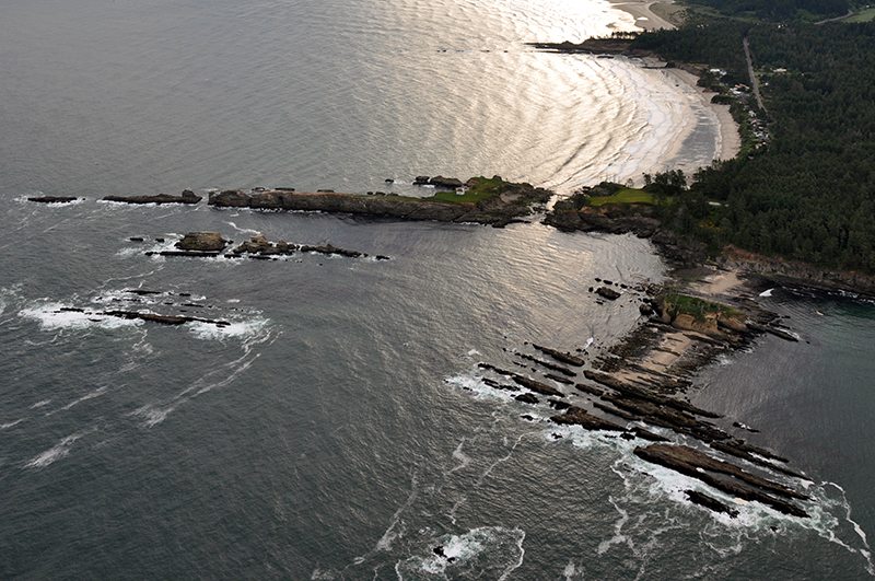
Gregory Point is a Marine Research Area
Gregory Point subtidal research reserve includes “all areas seaward of extreme low tide in the area defined by the points making lines from 43 20’35. 9’’ N. Lat., 124 22’50.3 W. Long. (point A) to 43 20’35.9’’ N. Lat., 124 22’53.7’’ W. Long. (point B), and seaward of extreme low tide from 43 20’24. 1’’ N. Lat., 123 22’32.7’’ W. Long. (point D) to 43 20’39.0’’ N. Lat 124 22’38.2’’ W. Long. (point C). Additionally, the entire Cape Arago Headland is identified by OPRD as an Intertidal Marine Protected Area for public awareness purposes only. This designation holds no special regulatory or enforcement powers.
Features
Key Resources
Seabird nesting sites on Lighthouse Island; extensive intertidal and subtidal rocky habitat between Lighthouse Island and Squaw Island. Harbor seals use rocks in the area as a haulout.
Site Uses
Primarily sightseeing from cliff above and general recreation at Sunset Beach nearby; some fishing from shore for rockfish and surfing at locally known access points; recreational fishing and SCUBA diving from boats launched at Sunset Bay during good weather. Designation of Gregory Point as a subtidal research reserve means all collection of shellfish and marine invertebrates is prohibited (see current ODFW fishing regulations for exact boundaries), except by scientific permit.
Access
Shore level is reached with difficulty via unofficial hiking trails through coastal forest in the Sunset Bay area, from a parking area at the old Coast Guard housing site off Lighthouse Way, by climbing over rocks at extreme low tide (very difficult) from Sunset Bay, or by boat.
Management
Site Management
A section of the area is adjacent to Sunset Bay State Park, managed by Oregon Parks and Recreation Department (OPRD) and the intertidal area is managed by ODFW as a subtidal research reserve area. Offshore rocks in the area are part of the Oregon Islands National Wildlife Refuge. OPRD manages the ocean shore recreation area.
Regulations
No take of shellfish and other invertebrates in all areas below the extreme low tide line within the area bound by: 43° 20.312’N, 124° 22.838’W, 43° 20.598’N, 124° 22.895’W, 43° 20.650’N, 124° 22.637’W, 43° 20.402’N, 124° 22.545’W
Ownership
- Submerged and submersible (intertidal) lands: Oregon Department of State Lands;
- Beach and most upland area: Oregon Department of Parks and Recreation;
- Other upland: U.S. Bureau of Land Management (former U.S. Coast Guard site), Confederated Tribes of the Coos, Lower Umpqua and Siuslaw Indians.