About
Pirate Cove is a Marine Research Area
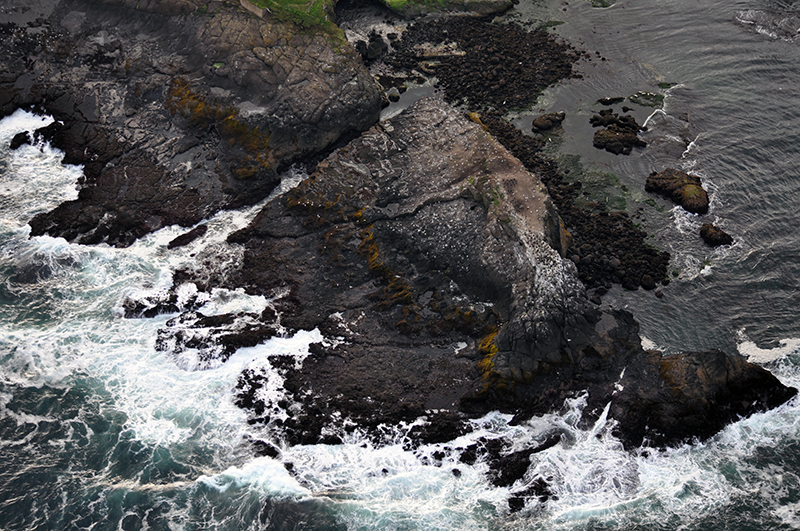
Pirate Cove Marine Research Area (MRA) Pirate Cove is located just to the south of Government Point approximately one mile north of Depoe Bay in Lincoln County, Oregon. The protected area encompasses all areas in Pirate Cove below extreme high tide east of a line drawn across the mouth of the cove, as defined by points at 44° 49’05.0” N. Latitude, 124° 04' 02.01" W Longitude and 44° 49.0' 8.8" N Latitude, 124° 04' 03.6" W Longitude.
Pirate Cove was recommended as a Research Reserve in the 1994 Territorial Sea Plan and was designated in 2019. The designation was revised to be a Marine Research Area in 2021.
Features
Key Resources
Pirate Cove features relatively undisturbed rocky intertidal habitats, seabird colonies including pigeon guillemots and western gulls, harbor seals pupping and haulout areas and some of the only offshore kelp beds north of Cape Arago.
Site Uses
Typical activities at Pirate Cove include whale watching, bird watching, walking, and photography. The upland is entirely under private ownership, although there is one public viewpoint of Pirate Cove on the south side of the cove with a public bench.
Access
There is a public access viewpoint from the Vista Street Public Access Point with views of the cove. The access point is maintained by the City of Depoe Bay with very limited parking in a residential neighborhood. Public access is also possible from the ocean, although the mouth of the cove is very narrow with only about a 300 ft opening. The upland is under private ownership.
Other public access points nearby include the Depoe Bay Scenic View Area, North Point Scenic View Area, and the Whale Watching Center located to the south of the site.
Management
Site Management
Wildlife found at Pirate Cove Marine Research Area (MRA) is managed by Oregon Department of Fish and Wildlife (ODFW). U.S. Fish and Wildlife Service (USFWS) manage the offshore rocks and islands found in Pirate Cove. Oregon Parks and Recreation Department (OPRD) manages rocky shoreline from the extreme-low water to the statutory line of vegetation.
For more information on shellfish regulations and licenses, visit the Oregon Department of Fish and Wildlife. The digital 2025 Oregon Sport Fishing Regulations book is available here. More information about scientific research permits from OPRD are available here.
Regulations
There are seven designated Marine Research Areas (MRA) in Oregon in rocky intertidal and subtidal areas. ODFW’s MRA regulations vary by site and are designated to limit sport harvest of most invertebrate species and manage scientific/educational take through a permit program (OAR 635-005-0260).
Pirate Cove MRA is closed to the take of all shellfish and other marine invertebrates. Sport fishing is allowed in Marine Research Areas. No collection of marine plants is allowed within the ocean shore in these areas, except by scientific research permit from OPRD (OAR 736-021-0090).
Regulations apply inside the site boundary: From the extreme high tide line on the upland rocks to the eastern line drawn across mouth of cove, defined by 44°49.083’N, 124°04.035’W and 44°49.146’N, 124°04.060’W.
Ownership and Jurisdiction
- Department of State Lands (DSL): Submerged and submersible land, use of the sea floor, removal of marine plants from subtidal habitat
- Oregon Parks and Recreation Department (OPRD): extreme-low water to the statutory line of vegetation, also responsible for permitting natural product removal (marine plants) from shore and intertidal habitat
- U.S. Fish and Wildlife Service (USFWS): Offshore rocks and islands above mean high waterline that are not connected to land at high tide, protections for birds and mammals
- Oregon Department of Fish and Wildlife (ODFW): Fish and wildlife and their habitats
- Oregon State Police (OSP): enforce fish and wildlife regulations
- City of Depoe Bay: Pirate Cove Scenic View Public Access Point on Vista Street
- The upland is entirely under private ownership.
For more details on agencies and government jurisdiction in the territorial sea, please see the Territorial Sea Plan Part 3: Rocky Habitat Management Strategy, Section C.